TREX: Tongass Rainforest Expedition
Hike the pristine Ward Creek Trail, lined by old growth spruce and hemlock. Hear the rushing waters of Ward Creek. See abundant berries, flowers and skunk cabbage in season.
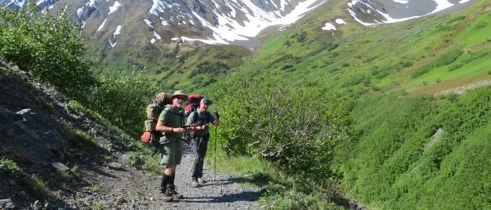
The Tongass National Forest is only accessible in Ketchikan by hiking. The trail is groomed to high U.S. Forest Service standards. It is moderately rolling and climbs to an elevation of about 100 feet over 2 miles, traversing a gentle mountain slope.
Guests can see a variety of wildlife including waterfowl, woodpeckers and small mammals. Bears are rare. While on the trail, visitors can become more closely acquainted with the issues in the Tongass, including resource and wildlife management and the local economy.
The Tongass Rainforest Expedition is a 2.5 hour trip from dock to dock. Our 15 passenger van escorts guests from the dock on a short trip along Ketchikan’s waterfront (10 minutes) on the way to the Tongass National Forest (total trip time: 20 minutes). Once at the scenic and remote Ward Lake site, guests begin their hike.
TREX provides an opportunity to encounter this special region on its own terms. The Tongass National Forest is a temperate rainforest. Tongass Rainforest Expedition is a partner with the Tongass National Forest. Hike Alaska’s Rainforest Book Your Expedition Now!
Phone: 907-617-8908
Ward Lake Nature Trail
Trail traversing 1.3 miles around Ward Lake located 8 miles north of Ketchikan by road. Trail is gravel surfaced and easy to hike. Signs interpreting old-growth forests are located along the trail. This is a heavily used trail connecting all of the facilities located around Ward Lake including campgrounds, picnic areas, and fishing sites.
Deer Mt, Silvis, & John Trail
The Deer Mountain Trailhead is reached by heading south on Tongass Highway 1/2 mile to Tatsuda’s Supermarket. Turn left onto Deermount St. Follow Deermount until it dead ends at T-intersection. Turn right at T, and proceed 1/4 mile to 1st left. Trailhead will be immediately on your right. Trail length is 9.9 miles from City of Ketchikan to Lower Silvis Lake. This trail is rated most difficult. It ascends steeply from the Ketchikan Trailhead to a spectacular overlook of Ketchikan and the surrounding area. It is a 2.5 mile hike to the Deer Mountain Recreation Cabin. From there, experienced hikers can continue past the summit. The trail crosses high alpine ridges and can be dangerous due to elevation and poor weather conditions. It is not well marked as it approaches Silvis Lakes. Dramatic alpine scenery makes the hike well worth the effort. Reconstruction of the first mile of the Deer Mountain Trail is just being completed.
Long Lake Trail
1.3 miles from Behm Narrows to Long Lake shelter. Access to trout fishing and scenery. Trail is in fair condition.
Low Lake Trail
2.1 miles from Thorne Arm to Low Lake, Fish Creek, and ending at Big Lake in Misty Fjords National Monument. Adjacent to the Low Lake trailhead is Gokachin Lake Trail proceeding from Thorne Arm up Fish Creek and ending at Star Lake also in Misty Fjords National Monument. Both of these trails access good fishing and are usable from the Fish Creek Cabin.
McDonald Lake Trail
1.3 miles from Yes Bay to Wolverine Island in McDonald Lake. Access to McDonald Lake Recreation Cabin and fishing.
Naha River Trail
5.4 miles from Naha Bay Dock to Heckman Lake Cabin on Heckman Lake. Trail passes the Naha River Shelter and the Jordan Lake Cabin. Excellent wildlife observation, fishing, camping, and hiking are accessed by this trail.
Orchard Lake Trail
1.2 miles from Shrimp Bay to Orchard Lake. Trail, rated more difficult, is steep to the crest of a ridge west of Orchard Lake, then drops into Orchard Lake. Trail provides access to Plenty Cutthroat Recreation Cabin. Trail provides scenic views of twin waterfalls on Orchard Creek, and trout fishing. Buoy located at Klu Bay.
Perseverance Trail
2.3 miles from trailhead to Perseverance Lake. Trailhead located approximately 8 miles drive from Ketchikan, across the road from the Ward Lake Recreation Area, near the entrance to 3 C’s Campground. Trail provides easy hiking access to fishing in Perseverance Lake, berry picking, and camping.
Reflection Lake Trail
2.3 miles from Short Bay in northern Behm Canal to Reflection Lake cabin. Recreation opportunities include Steelhead and salmon fishing in Short Creek along with trout and dolly varden fishing in Reflection Lake. This trail provides access to Reflection Lake Cabin. Because the bridge about 3/4 mile from saltwater is out, hikers must ford the stream. This is only possible during low water. Mooring buoy is located in Short Bay for small boat moorage.
Shelokum Lake Trail
2.2 miles from Bailey Bay to Lake Shelokum Shelter. Access to Bailey Bay Hot Springs-one of the most scenic areas you will ever experience! The trail is challenging. A landslide has buried the trail in one place. Expect to scramble over rocks on a steep sidehill in this area. Mooring buoy located at trailhead.
Swan Lake Trail
2 mile easy hike to Swan Lake and the Swan Lake Picnic Area located in upper Carroll Inlet. There is a dock at the trailhead. Hikers must check in with Ketchikan Public Utilities caretaker at Swan Lake before beginning hike. A phone at the trailhead is provided for this purpose.
Wolf Lake Trail
Trailhead is located 15 air miles north of Ketchikan in Moser Bay. 2.6 miles in length. Provides access to a 1930’s vintage Civilian Conservation Corps (CCC) 3-sided shelter at the outlet of Wolf Lake. Access to trout fishing and hunting. This is a primitive trail accessed by boat or plane. The creek between upper and lower Wolf Lakes must be forded.
Recreation Facilities Near Ketchikan
Margaret Creek Fish Ladder
Located 26 mile north of Ketchikan in Margaret Bay/ Traitors Cove. From July through October, numerous steelhead, coho, sockeye and pink salmon move upstream through this fish ladder. During this time, black bear viewing is outstanding from the observation platform at the top of the ladder (Photo, 184 KB) . What a great place to watch a bear fish! In August, during the peak of the pink run, as many as 10 bears may be feeding on the adult salmon above and below the fish ladder. The trail head that leads to the viewing platform is located on an existing road, approximately one mile from saltwater at Margaret Bay. When walking the trail please use extreme caution and make your presence known with noise! Like humans, black bears also use this trail for access to the creek where the fish ladder is located.
Naha Trailhead Picnic Area
Includes picnic shelter, picnic table on bluff, outhouse, and 1 mile loop trail to Roosevelt Lagoon. Black bears fishing in stream near picnic shelter are very common and have been known to relieve picnickers of their lunches. Use caution.
Silvis Lake Picnic Area
Includes 2 picnic tables and 1 fire ring at Lower Silvis Lake. Picnic area is located 1 mile up John Mountain Trail from the trailhead parking at the Beaver Falls Power House. Hike in access only.
Swan Lake Picnic Area
Picnic shelter on the scenic shores of Swan Lake. Accessed by 2 mile hike on Swan Lake Trail.
Ward Lake Recreation Area
8 miles north of Ketchikan on Ward Lake Road. Recreation area consists of 2 drive-in campgrounds (Signal Creek – 24 units, and Three C’s – 4 units), Ward Lake Group Day Use Area, Grassy Point Picnic Area, and Ward Lake Nature Trail (#739). This area is adjacent to hiking trails, and lake and stream fishing. Camping units are available for a $8.00 nightly fee. Advance reservations can be made for designated sites in Signal Creek Campground by calling 1-800-280-CAMP (TDD: 1-800-879-4496). All unreserved sites are available on a first-come / first-serve basis.
Fish Creek Wildlife Observation Site
The Fish Creek Wildlife Observation Site is a day-use recreation area in the Salmon River valley near Hyder, Alaska. It is operated by the U.S. Forest Service. Both brown (grizzly) and black bears are easily observed or photographed at the site as they fish for chum and pink salmon in the clear shallow waters of Fish Creek and Marx Creek. Enjoy the thrill of seeing wild bears in their natural habitat in this beautiful glacial river valley. Other wildlife frequently seen include nesting Canada geese, harlequin ducks, common mergansers, mink, beaver, bald eagles, and a wide variety of songbirds.
Bears use the site from mid-July through early September, following the arrival of salmon which return to the fresh waters of the creeks to spawn. The site is open from 6:00 am to 10:00 pm daily. Forest Service employees are at the site during these hours to provide information about the bears and salmon, enforce site rules, and answer questions from visitors. Facilities include a small parking area and an elevated viewing platform set in a grove of trees along the bank of Fish Creek. Bears and salmon can also be seen from the shoulders of the Salmon River Road and from a dike that separates Fish Creek and Marx Creek.
Visitors to the site should be aware that bears frequently walk on the road, through the parking lot, and along the dike. They are often very close to people. Remember that these are wild bears! Please respect their need for space in which to move between feeding areas and to avoid confrontations with more dominant bears. Move back and give them room to pass by if they approach, and follow the directions of on-site staff who help direct visitors to appropriate viewing areas.
Site Rules:
The following rules are required to provide for visitor safety and protection from bears. They will allow the bears to feed in a more natural and undisturbed setting. Please follow all directions from Forest Service personnel on the site, who are very knowledgable about the bears’ behavior.
- No food is permitted outside any vehicle. Please refrain from bringing any food to the site.
- Walk slowly and quietly in the site. Sudden movement and running will disturb the bears. Also refrain from shouting and talking loudly.
- Do not climb down the creek banks or go into the creek. Leave these areas to the bears so that they may be undisturbed by humans as they feed.
- Please try to limit the time spent on the dike and the main road. These are primary access routes to food sources for the bears. Although the bears are accustomed to people on the platform and in the parking lot, they need to be able to be unimpeded and roam freely throughout the site.
- No fishing is permitted from the streambanks in the site.
- Please do not use cameras with a flash as it startles the bears.
- Be alert – look around – the bears move freely along the road, dike, and between the creeks.
- Be patient – the bears will come but they are not in a zoo. They will come when people are quiet and behaving in an acceptable manner (i.e. staying in the areas bears expect to see people, such as on the viewing platform).
- Please remember to carry out with you everything you bring in.
Bear Postures:
What Are They Trying To Tell You?
Bears sometimes communicate to other animals and to humans through body postures:
Standing in profile to you, head lowered, and passively looking toward the distance may be a bear’s way of showing you his size, a polite way of telling you to move out of his space. Aggression is signaled by salivation, teeth chatter, hair raised on the hump back, and ears laid back along the sides of the head. Standing erect on hind legs is usually not an aggressive posture. When the bear’s head and nose are raised with ears forward, the animal may only be trying to identify noises and smells.
Getting To The Fish Creek Wildlife Observation Site:
This is the only bear-viewing site in Alaska that is accessible by highway. A 41-mile detour off the Cassiar Highway at Meziadin Lake Junction (on Highway 37A) brings you to the neighboring towns of Stewart, British Columbia, and Hyder, Alaska at the head of Portland Canal. Follow the gravel-surfaced Salmon River Road through Hyder and continue three miles north. A sign marks the Observation Site, and the parking area is on the left just past the Fish Creek bridge. Shuttle vans from Hyder and Stewart provide another way to get to the Observation Site for those who do not want to drive or park large RVs or trailers. These shuttle services are currently provided by Seaport Limosine in Stewart (ph: 250-636-2622) and by the Grandview Inn in Hyder (ph: 250-636-9174). Visitors are encouraged to use the shuttles to help minimize traffic congestion at the Observation Site.
Other Recreation Opportunities In The Area:
Fishing:
There are several access points for fishing the waters of lower Fish Creek, Moose Pond Creek, and the Salmon River. All of these are south of the Observation Site. Pink and chum salmon and Dolly Varden char are frequently caught. Contact the Forest Service Office in Hyder for information on fishing areas.
Titan Trail:
This 5-mile trail begins 1/4 mile north of the Fish Creek Wildlife Observation Site on the Salmon River Road. It crosses Fish Creek (no bridge – hikers must ford the creek) and climbs through old-growth forest and open avalanche slopes to the alpine ridges that form the US/Canada border. Excellent views of the Salmon River valley and the ice cap and glaciers are visible from several points along the trail.
Salmon Glacier:
The Salmon River Road climbs steeply out of the valley to end at the abandoned Grand Duc Mine past the Salmon Glacier. The road winds high above the glacier and provides spectacular views of mountains, alpine meadows, wildflowers, and the large T-shaped glacier which forms the headwaters of the Salmon River.
Let us know if you have any Questions